Digital Height Models
Digital height model products available in LGIA:
- the basic data of the digital height model is a set of classified aerial laser scanning points, where each point has known plane coordinates (X, Y) and altitude (Z). The model data are linked to the coordinate system LKS-92 TM and the Latvian normal height system LAS-2000.5. Basic data were obtained by aerial laser scanning method. The total density of the obtained points is not less than 4 p/m², the average density of the points characterizing the ground surface is not less than 1.5 p/m² (the basic data of the digital elevation model are available in the form of open data);
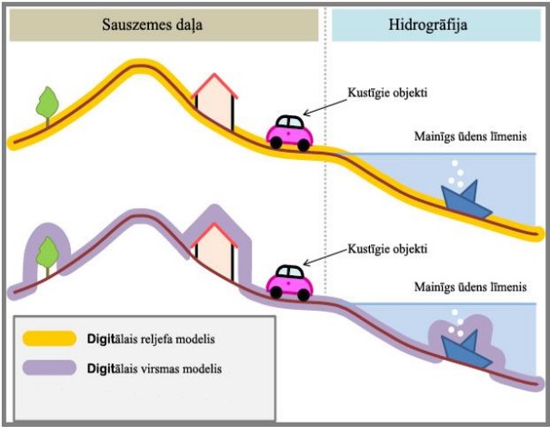
- a digital surface model is a set of points, a model of the elevation of the Earth's surface, which includes the vegetation, peaks of economic objects and other objects;
- visualized images of a digital surface model prepared from aerial laser scanning data with a resolution of 25 cm (available raster data format - TIFF and ECW) (example);
- digital surface model prepared from aerial laser scanning data with a resolution of 1 m (available raster data format - TIFF) (example);
- the digital terrain model is a set of points on the Earth's surface, without the peaks of vegetation, economic and other objects;
- basic data of the digital terrain model with a regular network step of 20 m from the data obtained by the laser scanning method (text ASCII data format available) (data available in the form of open data);
- basic data of the digital terrain model with a regular network step of 5 m from the data obtained by the laser scanning method (text ASCII data format available);
- visualized images of a digital terrain model prepared from aerial laser scanning data with a resolution of 25 cm (available in raster data format - TIFF and ECW) (example);
- digital terrain model prepared from aerial laser scanning data with a resolution of 1 m (available raster data format - TIFF) (example);
- digital terrain model for aeronautical purposes with a horizontal step of 3 arc seconds.
- digital terrain model, visualized in the form of horizontal - general terrain shapes in vector file format. The horizontal depicts general relief shapes and also reflects artificial embankments higher than 3 m. Step between horizontal - 1 m, highlighted horizontal - every 10 m. The data is supplemented by altitude marks and drop indicators. Horizontals are divided into levels according to height values (available data formats - DGN, Esri Shapefile, Esri File Geodatabase);
- digital elevation model
Principle and technical parameters of aerial laser scanning
Aerial laser scanning – an accurate and efficient method of receiving surface data from an aircraft with LiDAR (Light Detection And Ranging) technology.
LiDAR – remote sensing technology using visible light and infrared waves. The most important function of a laser is the continuous generation of a beam, and the reflection of this beam against an object, which allows to determine the distance to the object.
Aerial laser scanning system – a specially adapted set of equipment placed on board an aircraft to obtain information about the Earth's surface in the form of a three-dimensional cloud. Each point has specific spatial coordinates X, Y, Z.
LiDAR data, when processed with special software, can be used in several industries:
- geodesy and cartography;
- territorial planning;
- road construction planning;
- telecommunications and engineering management and planning;
- volume measurements;
- forestry management and planning;
- hydrology;
- in the analysis of natural elements;
- flood modeling;
- in archeology;
- vegetation research;
- in the field of real estate;
- other sectors of the economy.
Continuous aerial laser scanning of the territory of Latvia
The LGIA, in cooperation with the Ministry of Defense and other state institutions, conducted a study on the necessary priorities of the state territories and the necessary technical parameters.
Main technical parameters:
- the total density of the obtained points is not less than 4 p/m², the average density of the points characterizing the Earth's surface is not less than 1.5 p/m²;
- vertical accuracy of data up to 12 cm (2 sigmas with 95% confidence level) against the State Geodetic Network;
- horizontal accuracy of data up to 36 cm (2 sigmas with 95% confidence level) against the State Geodetic Network.
Explanation of height models