Overview map of the Republic of Latvia in scale 1: 250 000
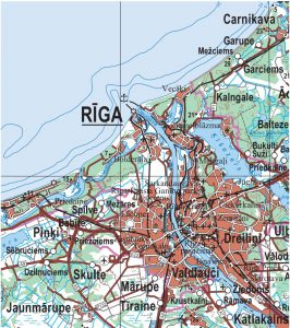
Overview map of the Republic of Latvia at a scale of 1: 250 000 (3rd edition) - displays information about all settlements, road network, vegetation (forests, swamps), river network, water bodies (large ponds, lakes), highlands and terrain.
Data of the territory of Latvia are available in the LKS-92 TM coordinate system. Map production time - 2020.
Geospatial data:
ArcGIS File Database (121MB)
GeoTIFF (457MB)
PDF
RESOURCE FILES
WMTS
Overview map of the Republic of Latvia at a scale of 1: 250 000 (2nd edition) - displays information about all settlements, road network, vegetation (forests, swamps), river network, water bodies (large ponds, lakes), highlands and relief. In the back of the map, extensive information is available about the length of the state border, the number of inhabitants in cities and villages, the highest mountains and the deepest lakes. The overview map of Latvia at a scale of 1: 250 000 was prepared in 2012.
Data on the territory of Latvia are available in the LKS-92 TM coordinate system. The main source material is the military Joint Operations Map (JOG) at a scale of 1: 250 000, 2nd edition.
Geospatial data:
GEOJSON (97,33MB)
TIFF (283MB)
ArcGIS File Database (121MB)
METADATI